Related Blog Posts
-
 06 December 2024
-
 30 November 2024
-
 28 November 2024
-
 28 November 2024
-
 22 November 2024
Latest Blog Posts
-
 12 December 2024
-
 07 December 2024
-
06 December 2024
-
30 November 2024
-
28 November 2024
Ağrı is one of the easternmost provinces of Turkey. It offers a unique experience to its visitors with its rich history and natural beauties. Places to visit in Ağrı include:
List of Places to Visit in Ağrı
Ağrı is a city with historical and natural beauties located in the Eastern Anatolia Region of Turkey. Some important places to visit in Ağrı are:
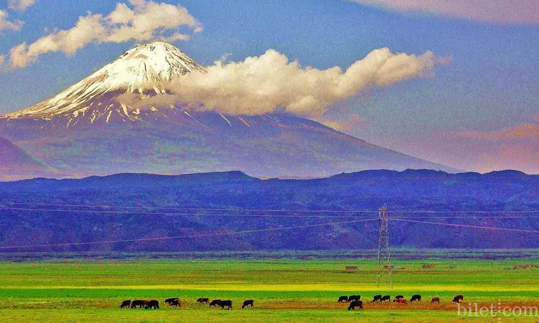
Mount Ararat
Mount Ararat is the highest mountain in Turkey and one of the most important symbols of the Eastern Anatolia Region. With an altitude of 5,137 meters, it is the highest mountain in Anatolia and the Lesser Caucasus Mountains. Mount Ararat is located at the intersection of the borders of Türkiye, Iran and Armenia.
Mount Ararat is an extinct volcano and its last eruption took place approximately 10,000 years ago. There are glaciers at the top of the mountain. Mount Ararat is visited by many local and foreign tourists every year. Special permission is required to climb to the top of the mountain.
Ishak Pasha Palace
Ishak Pasha Palace is a palace located in the Doğubayazıt district of Ağrı province of Turkey. The palace, whose construction started in 1685 and was completed in 1784, is a large building complex where Ottoman and Seljuk architecture can be seen together.
The architect of the palace is Mehmet Pasha, the son of Çolak Abdi Pasha, one of the Çıldır Atabeys. The palace was built in Doğubayazıt, the center of the Çıldır Atabeydom. It is estimated that 20,000 workers worked in the construction of the palace and approximately 1 million gold was spent.
Noah's ship
Noah's Ark is an ark prepared to protect Noah's family and other animals in the world from the world that God destroyed with a great flood because people indulged in evil, as described in the Genesis chapter of the Torah.
Noah's Ark is described as being 500 cubits long, 300 cubits wide and 30 cubits high. The ship was made of maple and cedar trees. There is enough room in the ark for Noah's family and all kinds of animals.
fish lake
Lake Balık is a lake located in the Doğubayazıt district of Ağrı province of Turkey. The lake has an area of 30 square kilometers. It is located at an altitude of 2,241 meters above sea level.
Fish Lake is a volcanic lake. The formation of the lake is based on volcanic eruptions in the region. There are many volcanic formations around the lake.
Diyadin Thermal Springs
Diyadin Thermal Springs is a spa center located in Diyadin district of Ağrı province of Turkey. The hot springs are spread over an area of 48 square kilometers.
Diyadin Thermal Springs is famous for its healing waters. Thermal spring waters are said to be good for rheumatism, liver, kidney and skin diseases because they contain bicarbonate, chloride, sulfate, calcium and carbon dioxide gas and their total mineralization is 1 g/lt.
Diyadin Canyon
Diyadin Canyon is a canyon located in Diyadin district of Ağrı province of Turkey. The canyon is 10 kilometers long and 50 meters wide.
Diyadin Canyon is a canyon formed by the Murat River. The formation of the canyon is based on volcanic eruptions that occurred in the region millions of years ago.
Meteor Pit
Meteor Pit is a natural wonder located in Ağrı province of Turkey. It is located 35 kilometers east of Doğubeyazıt district, approximately 2 kilometers northeast of Gürbulak Customs Gate.
The pit is approximately 60 meters deep and 35 meters in diameter. It has a cylindrical structure and has an opening at the top. The formation of the pit dates back to a meteorite impact that occurred in the region in 1892.
Eleşkirt Ski Resort
Eleşkirt Ski Center is a ski resort located in the Eleşkirt district of Ağrı province of Turkey. The center is 6 kilometers away from the district center.
The ski resort is located at an altitude of 1,840 meters. In the center, there is a 1600 meter long chairlift and two medium and difficult level tracks.
Doğubeyazıt Castle
Doğubeyazıt Castle is a castle located in the Doğubeyazıt district of Ağrı province. The castle was built on a hill consisting of steep rocks in a place called Belleburç, 7 kilometers away from the town center.
The exact construction date of the castle is unknown and it is estimated that it dates back to the Urartian period. The castle was later repaired by the Seljuks and Ottomans. The castle, which is in ruins today, is still an important tourism point.
Taşlıçay Waterfall
Taşlıçay Waterfall is a waterfall located in Taşlıçay district of Ağrı province of Turkey. The waterfall is located in the village of Ağır Toklu, 6 kilometers away from the town center.
The waterfall falls from a height of approximately 12 meters. The waterfall is surrounded by lush green forests. The view of the waterfall offers its visitors a unique experience.
Patnos Rocks
Patnos Rocks is a rocky area located in the Patnos district of Turkey's Ağrı province. The rocks are located in the village of Yalçınkaya, approximately 10 kilometers away from the town center.
The cliffs are approximately 1 kilometer long and 500 meters wide. The height of the rocks varies between 100 and 200 meters. The cliffs have a steep and steep structure.
Urartian Castle
Urartu Castle is a castle located in the Doğubeyazıt district of Ağrı province of Turkey. The castle was built on a hill consisting of steep rocks in a place called Belleburç, 7 kilometers away from the town center.
The exact construction date of the castle is unknown and it is estimated that it dates back to the Urartian period. The castle was later repaired by the Seljuks and Ottomans. The castle, which is in ruins today, is still an important tourism point.
Ice Cave
Ağrı Ice Cave is a natural cave located in Ağrı province of Turkey. The cave is located 25 kilometers northeast of Doğubeyazıt district and approximately 3 kilometers northeast of Hallaç village.
The cave is approximately 100 meters long, 50 meters wide and 10 meters high. The interior of the cave is covered with ice throughout the year. Inside the cave, there are various icicles and stalagmites.
Dough Dome
Hamura Tomb is a tomb located in the Hamur district of Ağrı. Kümbet is located on a hill northeast of the district center, overlooking the valley where the district was founded.
The construction of the tomb was started in 1802 by İbrahim Pasha, one of the grandchildren of İshak Pasha, and was completed in 1807. The tomb contains the graves of İbrahim Pasha and his family.
Might Bridge
Kudret Bridge is a natural bridge located in Diyadin district of Ağrı province of Turkey. The bridge is located on the Murat River, approximately 2 kilometers away from the town centre.
The bridge is approximately 30 meters high and 30 meters wide. The bridge was formed by the erosive effect of the Murat River.
Meya Caves
Meya Caves is a cave complex located in Diyadin district of Ağrı province of Turkey. The caves are located in Günbuldu village, 12 kilometers away from the district center.
The caves are approximately 500 meters long and 200 meters wide. Inside the caves, there are rooms and galleries of various sizes. The length of the largest chamber of the caves is approximately 100 meters.